This Kinder Reservoir peak district walk begins and ends at the Bowden Bridge Car Park in Hayfield and marks the start of the Kinder Trespass which happened in 1932. Thanks to this moment in history, the hills of the peak district are now available for everyone to enjoy.
There are two ways to start this kinder reservoir walk, the first is a simple circuit which will start at the Bowden Bridge Car Park, this route is approximately 4.5 miles.
The second is about a mile further but absolutely worth it in my opinion. Taking the second option will take in some beautiful scenery to the west before some spectacular views of Kinder reservoir.
KINDER RESERVOIR WALK
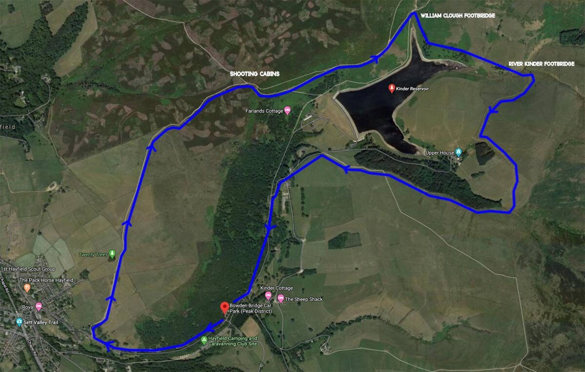
Route 1 marked red on the map
Approx. 4.5 miles
Total ascent approx. 250 meters
Difficulty. Easy
Start & endpoint. Bowden Bridge car park
165 Kinder Rd, High Peak SK22 2L
KINDER RESERVOIR PEAK DISTRICT
From Bowden Bridge Car Park turn left and follow the road up towards the reservoir for about 800 metres. Avoid turning off the road as there are several right turns that should be avoided. Eventually, you will come to the start of the walking trail. Just follow the path upwards towards the reservoir, the dam will be on you right. Making your way up to the dam wall you will soon start to see the views of Kinder reservoir and the mighty kinder scout ridgeline. your route is clear now, simply follow the path by the water's edge and continue right down the reservoir keeping the water to your right.
After a mile and a half, you will reach kinder reservoirs most northerly tip. This is the start of William clough and you will see a beautiful footbridge that will take you across the stream. When you have reached the other side, simply follow the path to the right which heads through some lovely silver birches.
Continue now for another mile and you will eventually end up at the river kinder which is the main source of the reservoir. Again here you will find a lovely footbridge that makes the crossing easy. After crossing the footbridge over the river kinder it's time to leave the waters edge and head over the hill towards Upper house. Upper house is the charming mansion that sits nestled in the hillside within some beautiful wooded areas.
You will want to look out for the copse of trees and head straight for it keeping it to your right. When you have reached the crest of the hill you will see the walking sign that directs you back to the kinder road. Just keep heading down now with the woodland to your right and you will eventually end up on the kinder road. Now just cross the river and head left back to the car park.
It's a beautiful walk and is suitable for the whole family.
WALKING KINDER RESERVOIR IN THE PEAK DISTRICT
Route 2 marked blue on the map
Approx. 5.5 miles
Total ascent approx. 350 meters
Difficulty. Easy-moderate
Start & endpoint. Bowden Bridge car park.
165 Kinder Rd, High Peak SK22 2LH
Route 2 is definitely my favourite and starts at Bowden Bridge Car Park and is approximately a mile longer than the previous route.
This time we head right out of the car park past the sportsman's inn. After around 400 meters or so you will come to the start of the famous snake path. Turn right by the walking sign and head up between the buildings directly uphill. It is signposted here and after a further 300 meters you will see the copse of trees called twenty trees. Head towards twenty trees and go through a kissing gate and follow the path across the moors. The views out to the west and hayfield are beautiful. In the distance to the north you will start to see two white buildings, these are shooting cabins and they are a good marker to head towards.
Before reaching the cabins you will turn to your right over the brow of the hill you will see the spectacular and panoramic views of Kinder reservoir. Head down the hill for a little while and you will reach a dry stone wall that marks your path following the reservoir which will now be on your right. Follow this path until you reach the footbridge that crosses William clough. You will now be able to continue the same route as above from the William clough footbridge.
I hope you enjoy walking this route as much as me. To see more, take a look at the video below where I show footage of the whole route.


